Tag: Ocean

  • Scientists Reveal: South Africa Is Emerging From The Ocean

    Scientists Reveal: South Africa Is Emerging From The Ocean

    As climate change accelerates, South Africa is not only experiencing increased heat and dryness—it’s also gradually rising by as much as 2 millimeters per year, according to new research.
    Image Credits: Pixabay

    As climate change accelerates, South Africa is not only experiencing increased heat and dryness—it’s also gradually rising by as much as 2 millimeters per year, according to new research.

    While scientists already recognized this upward movement, they previously attributed it to mantle flow beneath the Earth’s crust in the region.

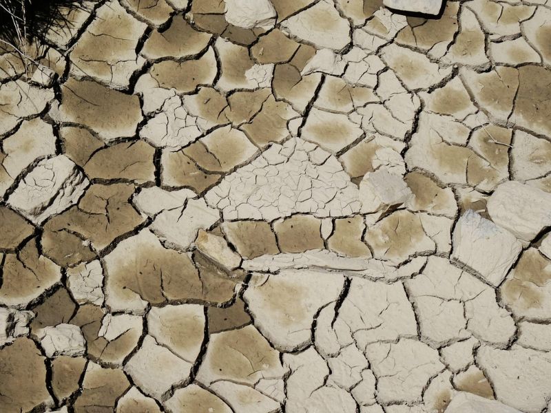
    However, the new study links the uplift to recent droughts and the resulting loss of surface water, a pattern associated with global climate change.

    Data from a network of global navigation satellite system (GNSS) stations across South Africa made this finding possible. Originally intended for atmospheric studies, the network delivers highly accurate measurements of elevation changes at different locations.

    “Between 2012 and 2020, the data showed an average elevation increase of 6 millimeters,” says geodesist Makan Karegar from the University of Bonn.

    From Mantle Activity to Water Loss

    Previously, scientists attributed the Quathlamba hotspot—a localized swelling of Earth’s crust caused by an upswelling of material from a mantle plume beneath the area—to explain the ongoing uplift.

    “But we’ve now tested an alternative explanation,” says Karegar. “We believe that the loss of groundwater and surface water may also be causing the land to rise.”

    To investigate this theory, Karegar and his team analyzed GNSS elevation data alongside rainfall patterns and other hydrological indicators throughout South Africa.

    A clear correlation emerged: regions that experienced severe droughts in recent years showed the most significant uplift.

    The most notable rise occurred during the intense 2015–2019 drought, a time when Cape Town faced the looming threat of “day zero”—the projected day the city would run out of water.

    Image Credits: The change in height of different GPS stations (red = rising; blue = sinking). The rise was particularly pronounced between 2015 and 2019. (AG Kusche/University of Bonn)

    Satellite Data Offers Broad Insight into Water Loss

    The researchers also incorporated data from the GRACE satellite mission—a collaboration between NASA and the German Aerospace Center designed to track Earth’s gravity field and shifts in water distribution.

    “These measurements help us determine changes in total water storage, including surface water, soil moisture, and groundwater,” explains Christian Mielke, a geodesist at the University of Bonn. “However, the satellite’s spatial resolution is limited to several hundred kilometers.”

    Even with that limitation, the GRACE data backed up the team’s theory: areas with reduced water mass showed greater land uplift at nearby GNSS monitoring stations.

    To gain more detailed insights, the researchers turned to hydrological models, which offered higher-resolution analysis of how drought conditions affect the water cycle.

    “This data also indicated that the land uplift is largely due to drought and the resulting loss of water mass,” says Mielke.

    Mantle Plume and Moisture Loss Drive Uplift

    The researchers propose that, alongside the upward force from a mantle plume, the reduction of moisture in the Earth’s crust may also be contributing to the land’s rising.

    This finding highlights yet another way climate change is reshaping our planet—but it may also have practical benefits.

    GNSS data, which are affordable and easy to gather, could serve as a new tool for monitoring water scarcity, including vital groundwater reserves that are often overdrawn for farming and other human activities.

    With droughts posing a serious threat not only in South Africa but globally, this research could offer a valuable method for tracking water availability and managing water resources more effectively.


    Read the original article on: Sciencealert

    Read more: Climate Change is Reshaping Wine Regions Worldwide, With Uneven Effects

  • New Clues Suggest A Hidden Ocean Of Water Buried Beneath Mars

    New Clues Suggest A Hidden Ocean Of Water Buried Beneath Mars

    Growing evidence suggests that a hidden secret beneath Mars' dusty red plains could change our understanding of the planet: a massive reservoir of liquid water, buried deep within its crust.
    Credit: Pixabay

    Growing evidence suggests that a hidden secret beneath Mars‘ dusty red plains could change our understanding of the planet: a massive reservoir of liquid water, buried deep within its crust.

    Mars, dotted with remnants of ancient water, has fascinated scientists as they unravel the mystery of what happened when the planet became cold and dry.

    Our latest study might provide a solution.NASA’s InSight data show seismic waves slow down between 5.4 and 8 km below the surface, likely due to liquid water.

    The enigma of the vanishing water

    Mars was not always the lifeless desert it is now. Billions of years ago, during the Noachian and Hesperian periods (4.1 to 3 billion years ago), rivers created valleys and lakes sparkled across the surface.

    As Mars’ magnetic field weakened and its atmosphere thinned, much of the surface water disappeared. Some escaped into space, some froze in the polar caps, and some became trapped in minerals.

    Credit: Four billion years ago (top left), Mars may have hosted a huge ocean. But the surface water has slowly disappeared, leaving only frozen remnants near the poles today. (NASA)

    However, evaporation, freezing, and minerals don’t fully explain all the water that once covered Mars. Estimates  suggest the ‘missing’ water could form an ocean on Mars, at least 700 meters deep, possibly up to 900 meters.

    One theory is that the missing water infiltrated the crust. “During the Noachian period, meteorites struck Mars, possibly creating fractures that directed water underground.”

    Far below the surface, higher temperatures would have kept the water in liquid form, unlike the frozen layers closer to the surface.

    A seismic image of Mars’ crust

    In 2018, NASA’s  InSight lander landed on Mars to study the planet’s interior using an extremely sensitive seismometer.

    By analyzing a specific type of vibration known as “shear waves,” we discovered a notable underground irregularity: a layer located 5.4 to 8 kilometers beneath the surface where these vibrations travel more slowly.

    This ‘low-velocity layer’ likely consists of highly porous rock saturated with liquid water, similar to a sponge. It resembles Earth’s aquifers, where groundwater fills the pores of the rock.

    Credit: Cassini Crater on Mars. (UAESA/MBRSC Hope Mars Mission/EXI/Andrea Luck/CC BY 4.0)

    We estimated that the “aquifer layer” on Mars could contain enough water to form a global ocean 520–780 meters deep, which is several times the amount of water found in Antarctica’s ice sheet.

    This volume aligns with estimates of Mars’ “missing” water (710–920 meters), once losses to space, water trapped in minerals, and current ice caps are taken into account.

    Meteorite impacts and marsquakes

    Our discovery was made possible by two meteorite impacts in 2021 (S1000a and S1094b) and a marsquake in 2022 (S1222a). These events generated seismic waves that traveled through the crust, like ripples from a stone dropped in a pond.

    Credit: The crater caused by meteorite impact S1094b, as seen from NASA’s Mars Reconnaissance Orbiter. (NASA/JPL-Caltech/University of Arizona)

    Growing evidence suggests a hidden secret beneath Mars‘ dusty red plains: a vast reservoir of liquid water, trapped deep within the crust, that could change our understanding of the Red Planet.

    Mars is marked by remnants of ancient bodies of water, but the mystery of where it all went as the planet became cold and dry has fascinated scientists for years.

    We computed “receiver functions,” which are patterns of these waves as they reflect and reverberate between layers in the crust, similar to echoes mapping a cave. These patterns allow us to identify boundaries where rock properties shift, uncovering a water-saturated layer 5.4 to 8 kilometers below the surface.

    The significance of this

    Liquid water is crucial for life as we understand it. On Earth, microbes thrive in deep, water-saturated rock.

    Could similar life forms, possibly remnants of ancient Martian ecosystems, survive in these underground reservoirs? There’s only one way to find out.

    The water could also be vital for more complex life, including future human explorers. When purified, it could provide drinking water, oxygen, or even fuel for rockets.

    While drilling kilometers deep on a distant planet presents significant challenges, our data, gathered near Mars’ equator, suggests there may be other water-rich areas, such as the icy mud reservoir in Utopia Planitia.

    What lies ahead for Mars exploration?

    Our seismic data represents just a small portion of Mars. Additional missions equipped with seismometers are necessary to map potential water layers throughout the entire planet.


    Read the original article on: Sciencealert

    Read more: Ancient Martian Beaches Reveal Evidence of Oceans on the Red Planet

  • A Robotic Sea Turtle Might Soon Be Gliding Through an Ocean Near You

    A Robotic Sea Turtle Might Soon Be Gliding Through an Ocean Near You

    When designing a fast, agile, and adaptable underwater robot, why not take inspiration from nature? That’s precisely what China’s Beatbot did with its bio-inspired Amphibious RoboTurtle.
    A head-on view of the Beatbot Amphibious RoboTurtle, on display last week at CES 2025
    Beatbot

    When designing a fast, agile, and adaptable underwater robot, why not take inspiration from nature? That’s precisely what China’s Beatbot did with its bio-inspired Amphibious RoboTurtle.

    Unveiled as a prototype at CES last week, this autonomous robot is built for tasks like ecological research, environmental monitoring, and disaster response.

    Equipped for Advanced Exploration

    It can be outfitted with various hardware, including a water sampling unit, GPS module, ultrasonic sensors, and AI-powered cameras. These cameras are said to enable the robot to detect and respond to environmental changes while autonomously tracking or following marine animals.

    The RoboTurtle charges its battery via a solar panel in its back
    Beatbot

    The RoboTurtle moves quietly by flapping its multi-jointed bionic legs, which its designers claim makes it less disruptive to wildlife compared to propeller-driven robots. It also includes a buoyancy control system, enabling it to ascend and descend in the water column and float at the surface.

    Sustainable and Versatile Operation

    While floating, the robot can recharge its battery using solar panels on its back and transmit collected data or receive updated mission instructions via satellite. Its powered legs even allow it to crawl onto beaches, though it’s unlikely to win any speed contests on land.

    According to its designers, the RoboTurtle can be deployed much quicker than most other AUVs (autonomous underwater vehicles)
    Beatbot

    Impressive Endurance and Natural Speed

    Although exact performance details are still under wraps, a Beatbot representative shared that the RoboTurtle swims at a speed comparable to a real sea turtle and could potentially operate all day with periodic solar-charging breaks.

    Beatbot, best known for its pool-cleaning robots, does intend to commercialize the Amphibious RoboTurtle. Its size and capabilities will be customized to meet the specific needs of each client.

    However, it won’t be the only robotic turtle in the ocean. Research teams from ETH Zurich, the ARROWS project, and the National University of Singapore are also developing their own swimming turtle-inspired robots.


    Read the original article on: New Atlas

    Read more: An Impressive Robotic Hand Now has the Ability to Manipulate Objects it is Holding

  • Dark Oxygen Discovered in the Ocean: What Does It Mean?

    Dark Oxygen Discovered in the Ocean: What Does It Mean?

    Credit: Pixabay

    Plants, whether in the ocean or on land, largely produce the oxygen essential for intelligent life as we know it through photosynthesis of carbon dioxide. However, new research suggests that depths with no light might generate oxygen without relying on living organisms.

    The authors of the study, published in Nature Geoscience, collected samples of marine sediments to measure oxygen consumption at the ocean floor. They expected reactions with sediments and organisms to decrease oxygen levels, but they discovered something surprising: in some experiments, oxygen levels actually increased, prompting questions about how this oxygen was being produced.

    Polymetallic nodules from the ocean floor. (Franz Geiger/Northwestern University)

    The researchers found that this “dark” oxygen production only occurred in the presence of polymetallic nodules and metal-rich sediments, known as metalliferous deposits. They believe these nodules contain the necessary combination of metals and are dense enough to conduct an electrical current, allowing electrolysis to split hydrogen and oxygen from water molecules (H₂O).

    The team also suggests that the amount of oxygen generated may vary depending on the concentration and composition of nodules on the ocean floor. This study is part of an investigation into the impact of mining metals like lithium, cobalt, and copper—resources used in rechargeable batteries and electrical wiring—in pursuit of sustainable benefits for humanity and the planet.

    The research focuses on the Clarion-Clipperton Zone in the Pacific Ocean, where vast reserves of these metals lie between Hawaii and Mexico. However, scientists warn that large-scale mining in this area may cause irreversible damage to marine ecosystems, and many countries are calling for a moratorium to protect these fragile habitats.

    Dark Oxygen and Life

    This discovery may have implications for life elsewhere. Oxygen is crucial for complex life, and photosynthesis, which generates oxygen as a byproduct, is what enabled the biodiversity we know. However, the finding that metal-rich nodules can generate oxygen suggests an additional oxygen source for the biosphere.

    To fully understand the impact of these nodules on evolution, we still need to investigate more about the origins and formation of these deposits. Research like this highlights just how much we still don’t know about the origins of life on Earth.


    Read the original article on: Science Alert

    Read more: Earth’s Water is Rapidly Losing Oxygen, Creating a Major Threat

  • A New Type of Plastic Breaks Down in the Ocean More Quickly than Paper

    A New Type of Plastic Breaks Down in the Ocean More Quickly than Paper

    Researchers have spent recent years investigating which type of plastic biodegrades most rapidly in marine environments, as millions of tons of plastic enter our oceans each year. They discovered that a common bioplastic, which has been in use for over a century, biodegrades quickly, and they have figured out ways to speed up this process.
    A prototype straw (who would ever have thought those two words would be used together?) developed by Eastman made of foam CDA for testing its biodegradability 
    WHOI

    Researchers have spent recent years investigating which type of plastic biodegrades most rapidly in marine environments, as millions of tons of plastic enter our oceans each year. They discovered that a common bioplastic, which has been in use for over a century, biodegrades quickly, and they have figured out ways to speed up this process.

    Cellulose diacetate (CDA) is derived from cellulose, a natural polymer found in plant cell walls, especially in cotton and wood pulp. This bioplastic has been around since the late 1800s and is used in a variety of products, from sunglasses frames and cigarette filters (its most common application) to photography film and many other items in our daily lives.

    Fastest-Degrading Bioplastic Found in Seawater

    Researchers at the Woods Hole Oceanographic Institution (WHOI) have found that CDA is the fastest-degrading type of plastic in seawater, technically classified as a bioplastic. With a simple modification known as “foaming,” which makes the bioplastic porous, CDA degrades 15 times faster than solid CDA and even more quickly than paper.

    We applied foundational knowledge to create a new material that meets consumer needs while degrading in the ocean faster than any other plastic we know of, including paper,” said Collin Ward, a senior author of the study. “This represents a significant success in a field that often emphasizes the negative aspects of plastic pollution rather than pursuing solutions.”

    The structure of foam CDA before and after the 36-week seawater test
    WHOI

    In a 36-week test, CDA foam submerged in continuously flowing seawater tanks lost 65-70% of its original mass. In contrast, Styrofoam, a common plastic found in every ocean worldwide, demonstrated no degradation during the same time frame.

    Polystyrene, also known as Styrofoam, may change shape, but does not biodegrade at all after 36 weeks in seawater
    WHOI

    Ward and other WHOI scientists collaborated with Eastman, a bioplastic manufacturing company that provided materials, funding, and co-authorship for this and previous studies.

    Controlled Laboratory Environment for Marine Research

    The research was conducted in a controlled laboratory environment using continuously flowing seawater sourced from Martha’s Vineyard Sound near Cape Cod, Massachusetts. This setup allowed researchers to regulate light, temperature, and other variables to simulate dynamic ocean conditions.

    In January of this year, the results of a previous 16-week WHOI study were published. That study utilized the same seawater tank to compare eight different types of straws made from CDA, polyhydroxyalkanoates (PHA), polylactic acid (PLA), polypropylene (PP), and paper.

    Different straw materials after their 16 weeks of being continuously exposed to seawater
    WHOI

    The PLA and PP straws showed no measurable signs of degradation, while the other straws degraded by up to 50%.

    Foam CDA Straw Outperforms Solid and Paper Straws

    In comparing the prototype foam CDA straw to the solid CDA straw, researchers found that the foam CDA straw degraded 190% faster than the solid version, even outpacing the paper straw (which, fortunately, is a good thing since paper straws have a terrible taste). This led to the recent focused study by WHOI on foam CDA.

    Building on the success of foamed CDA, Eastman has introduced a biodegradable and compostable tray designed to replace conventional Styrofoam trays used for meat packaging, which do not biodegrade in any natural environmental conditions, whether on land or in the sea.

    Eastman’s new foam CDA tray for packaging meat to replace typical “forever” polystyrene trays
    Eastman

    Read the original article on: New Atlas

    Read more: Alarming Microplastics Found in Human Brains

  • Unlocking Uranium from Oceans: How Rare-Earth Metal Could Simplify and Economize Extraction

    Unlocking Uranium from Oceans: How Rare-Earth Metal Could Simplify and Economize Extraction

    Uranium stone, a very radioactive element. Credit: RHJPhtotos/Istockphoto.

    Discovering uranium in 1789 initially led to its application as a colorant in pottery. However, over time, it has transitioned into a coveted resource, serving the nuclear energy industry and medical field. This transformation underscores its increasing importance and utility.

    Abundance and Detection Advantage

    Uranium, more abundant than gold, possesses an innate advantage: it emits a distinctive radiation signature as it decays, simplifying its detection. 

    Historically, uranium supplies have comfortably met demand. However, concerns have arisen due to the global shift towards cleaner energy, like nuclear power, which necessitates securing new supplies.

    The Challenge of Oceanic Uranium

    A significant repository of uranium resides in the world’s oceans, exceeding what’s found in terrestrial deposits by over a thousandfold. Yet, the obstacle to its utilization lies in its extreme dilution in seawater. 

    This arises from the substantial presence of other substances like salt and minerals, such as iron and calcium, far outweighing uranium.

    The Quest for an Effective Extraction Technique

    Dr. Jessica Veliscek Carolan and her team have explored layered double hydroxide (LDH) materials. These highly adaptable materials exhibit promise in uranium extraction and other metals.

    LDH materials possess layers with positive and negative charges that can be customized for the selective extraction of specific substances, with uranium being a primary focus.

    Experiments simulating seawater conditions led to the refinement of the extraction technique. Notably, the introduction of neodymium proved highly efficient in isolating uranium from abundant elements in ocean water.

    Beyond Uranium Harvesting: A Solution for Radioactive Wastewater

    This breakthrough offers a means to gather new uranium supplies and the potential to address the radioactive wastewater generated by the nuclear industry. The simplicity and cost-effectiveness of producing these materials make them a promising choice for large-scale uranium extraction.

    This innovation holds the promise of revolutionizing uranium extraction from oceans and contributes to improving cleaner, sustainable energy sources.


    Read the original article on Energy Advances.

    Read more: Nuclear Fusion Produces Net Positive Energy in Breakthrough Experiment.

  • Hurricanes’ Deep Water Impact: Climate Effects Reaching Far and Wide

    Hurricanes’ Deep Water Impact: Climate Effects Reaching Far and Wide

    Scientists have discovered proof that typhoons/hurricanes can force warm water into the depths of the ocean, transporting it to distant locations.
    Credit: Unsplash.

    Scientists from the Scripps Institution of Oceanography at the University of California, along with a colleague from Brandeis University and two from Oregon State University, have discovered proof that typhoons/hurricanes can force warm water into the depths of the ocean, transporting it to distant locations.

    Their findings, posted in the Proceedings of the National Academy of Sciences, involved examining the state of the ocean prior to and following three typhoons that occurred in certain areas of the Philippine Sea.

    Previous studies have illustrated that the formation of typhoons and hurricanes is initiated by the evaporation of warm tropical water into the atmosphere. While considerable research has focused on the effects of these storms on populated land areas, little attention has been given to understanding their impact on the ocean.

    Investigating the Impact of Typhoons on the Philippine Sea through a Sailing Expedition

    To bridge this knowledge gap, a group of researchers embarked on a sailing expedition across the Philippine Sea in the autumn of 2018, coinciding with the formation of three typhoons. This allowed them to investigate the repercussions of these storms on the ocean. The team deployed probes into the sea to measure water movement and temperature before and after the typhoons made landfall.

    Their findings revealed that each typhoon pushed warm surface water downward into the depths of the ocean. Additionally, the storms caused turbulence in the water, leading to the mixing of warm water from the upper layers with colder water from below. Subsequently, underwater waves generated by the typhoons forced the warmer water to sink further, while the sun reheated the cooler water at the surface.

    The researchers observed that the warm water descended to depths of 300 meters and persisted for a minimum of three weeks after the passage of a cyclone.

    Furthermore, the researchers found that once the warm water was pushed downward, it was carried away by deep ocean currents. They found evidence suggesting that this warm water from the typhoons reached the coasts of Ecuador and California, propelled by these currents.

    Upon reaching the coast, the water ascended to the surface through shoaling currents and turbulent mixing. The team postulated that the movement of warm ocean water by typhoons and hurricanes could have implications for weather conditions in far-flung regions as the water resurfaces.


    Read the original article on PHYS.

    Read more: The Ocean Colour System Gets a ‘Refresh,’ Permitting More Precise and Accurate Measurements.